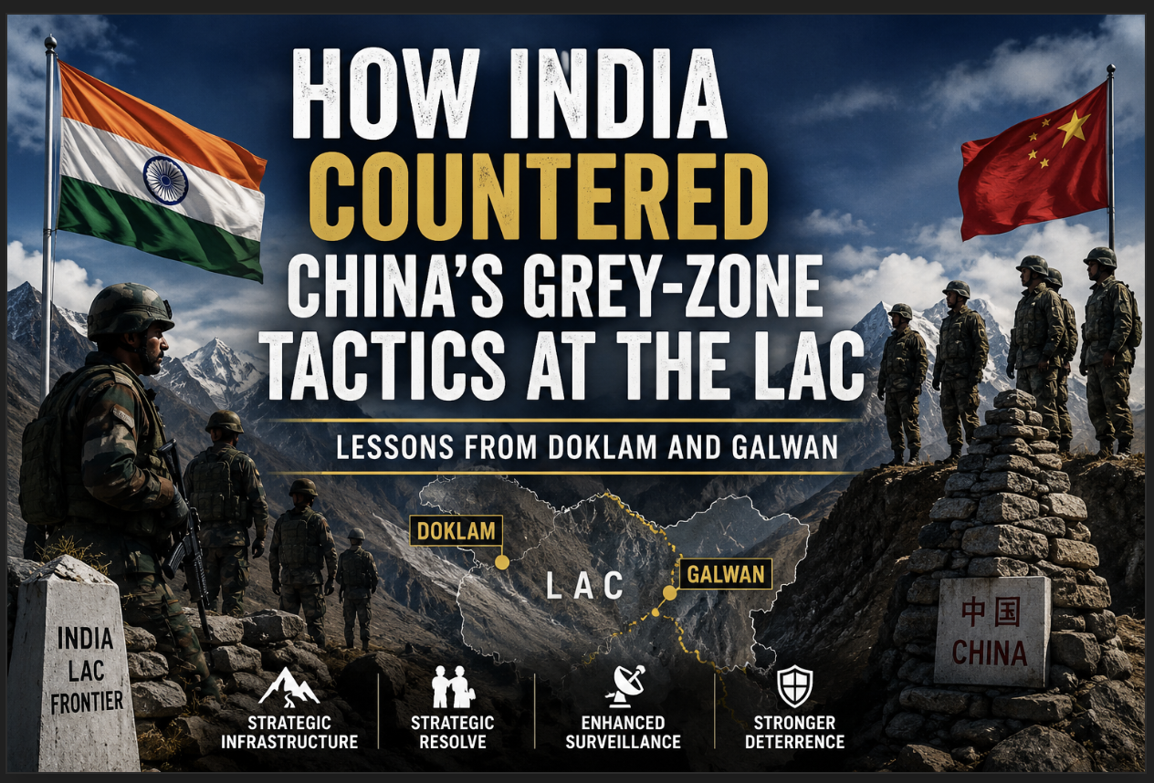
From the 73-Day Doklam Standoff to the Blood-Soaked Banks of Galwan — A Deep-Dive Analysis of India’s Strategic Counter to Beijing’s Salami-Slicing
A Road, a Ridge, and a Strategic Gamble
India countered Chinese grey-zone tactics at the LAC through infrastructure development, forward deployment and political resolve. On the morning of 17 June 2017, a column of People’s Liberation Army engineers rolled into the Doklam Plateau with earthmovers, bulldozers, and tactical road-building machinery. The destination was simple: the Zompelri Ridge, a high ridgeline from which Chinese artillery could peer straight down at India’s most dangerous geographic vulnerability, the 22-kilometre strip of land connecting mainland India to its entire north-eastern frontier.
The following day, roughly 270 armed Indian soldiers crossed the Sikkim border to stop them. Backed by two bulldozers of their own. What followed was 73 days of eyeball-to-eyeball standoff at altitudes above 14,000 feet, a confrontation that grabbed global headlines and forced strategic analysts to re-examine a fundamental question: can a smaller power actually call China’s bluff on its own borders?
The answer, it turned out, was yes. Three years later, in a narrow river valley in Ladakh, India did it again, this time at the cost of twenty of its own soldiers.
These two episodes — the Doklam standoff of 2017 and the Galwan clash of 2020 — are not simply dramatic military confrontations. They are case studies in how India recognised, absorbed, and effectively countered what strategists call grey-zone warfare: the calculated use of roads, villages, patrols, and incremental encroachment to alter territorial realities without ever firing an official shot. India countered Chinese grey-zone tactics at the LAC not through superior firepower, but through strategic clarity, pre-emptive infrastructure development, and the kind of political resolve that Beijing consistently underestimates in its neighbours.
Why Grey-Zone Warfare Matters: The Invisible War Along the Himalayas
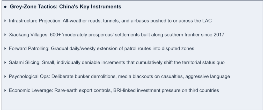
India Countered Chinese Grey-Zone Tactics at the LAC. China has not fought a sustained conventional war since its bruising 1979 conflict with Vietnam, which ended in a tactical embarrassment despite Beijing claiming victory. Since then, the PLA has overwhelmingly preferred a different instrument: territorial accumulation without formal warfare.
The logic is straightforward. In the South China Sea, China built artificial islands, converted them into military bases, and confronted the world with an established fact. In the Himalayas, the playbook involves roads into disputed territory, strategically placed villages that create civilian demographics in grey zones, and patrols that push forward inch by inch until a new normal is established. By the time an adversary mobilises a diplomatic or military response, the map has already shifted.
This strategy works for four distinct reasons. First, the ambiguity of the Line of Actual Control — which runs 3,488 kilometres through some of the world’s most remote and poorly surveyed terrain — means “who was where first” is often a matter of competing maps rather than clear law. Second, the PLA has invested massively in border infrastructure: all-weather roads, airbases, tunnel networks, and surveillance systems that give it mobility advantages India is only now beginning to match. Third, the threshold for a military response is high. Nuclear-armed neighbours, global economic interdependence, and diplomatic cost-calculations create space for China to operate just below the level that triggers formal retaliation. Fourth, democracies like India face domestic scrutiny and media pressure that authoritarian systems do not.
And yet, India’s experience from 2017 to 2024 suggests that this playbook has encountered its most consistent resistance along the Himalayan frontier.
“Roads, villages, and patrols have become the ammunition of 21st-century territorial competition. India learned this early — and responded in kind.”
Why Doklam Mattered: The Chumbi Valley Strategic Calculus
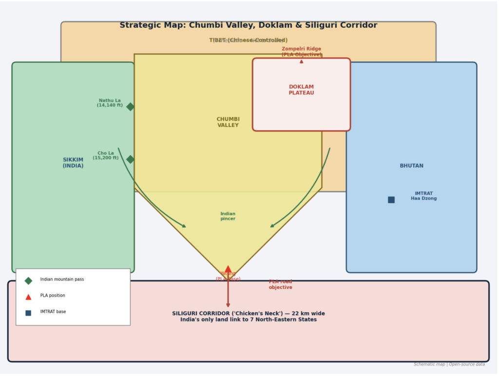
To understand Doklam, you have to understand the Chumbi Valley, and to understand the Chumbi Valley, you have to look at a map and feel a slight chill.
The valley is a narrow wedge of Tibetan territory shaped roughly like a dagger: pointing south between Sikkim to its west and Bhutan to its east. At the base of this dagger sits Yatung, the main Chinese military town at lower elevation than the ridges on either side. At its southern tip, the valley opens toward the plains of West Bengal — and specifically toward the Siliguri Corridor, the 22-kilometre-wide land bridge that connects mainland India to Assam, Arunachal Pradesh, Meghalaya, Nagaland, Manipur, Mizoram, and Tripura. Seven states. The entirety of India’s north-east.
India has historically had the upper hand in this geography. The 17th Mountain Division — the Black Cat Division — is permanently stationed in East Sikkim, holding the critical mountain passes that look down into Chumbi. Nathu La (14,140 ft) and Cho La (15,200 ft) give Indian forces commanding vertical and visual advantage over lower-lying Chinese positions below. If the PLA tried to march through the valley, Indian forces could execute a pincer from both east and west, catching them in narrow terrain with no room to manoeuvre.The Doklam standoff remains one of the clearest examples of how India countered Chinese grey-zone tactics at the LAC through rapid deployment and strategic restraint.
But that calculus changes if China gains control of the Doklam Plateau. Doklam sits at the top-right lip of the Chumbi Valley- an area of flat, strategically crucial high ground where the borders of India, China, and Bhutan converge. China controlling Doklam broadens its narrow wedge, gives troops elevated room to manoeuvre, and critically allows it to bring heavy armour, artillery, and logistics vehicles up to the Zompelri Ridge via a motorable road. From that ridge, the Siliguri Corridor is clearly visible and within artillery range. A Chinese engineering team with bulldozers at Doklam was not a minor provocation. In military terms, it was preparation of the battlespace.
India’s Pre-Positioned Assets: IMTRAT, DANTAK, and the Black Cats
India countered Chinese grey-zone tactics at the LAC by combining infrastructure development with forward military deployment. India’s ability to respond within 24 hours in 2017 was not improvised. It was the product of six decades of quiet strategic positioning.
The Indian Military Training Team (IMTRAT), established in 1961–62, is India’s oldest overseas military mission. Permanently headquartered at Haa Dzong in western Bhutan, IMTRAT gives India a continuous, treaty-sanctioned military presence directly east of the Chumbi Valley, right on China’s flanking exposure. Alongside it, Project DANTAK, launched in 1961 by the Border Roads Organisation — has constructed and maintained all critical military-grade roads, airfields, helipads, and bridges across Bhutan. These are not civilian amenities. They are the arteries through which Indian forces can move rapidly during a crisis.
When China arrived at Doklam with earthmovers, India had the legal basis (Bhutan’s 2007 Friendship Treaty includes security provisions), the physical infrastructure (DANTAK roads), the forward presence (IMTRAT at Haa), and the tactical positioning (17th Mountain Division at Cho La and Nathu La) to respond within hours.
Operation Juniper: How India Halted China at Doklam
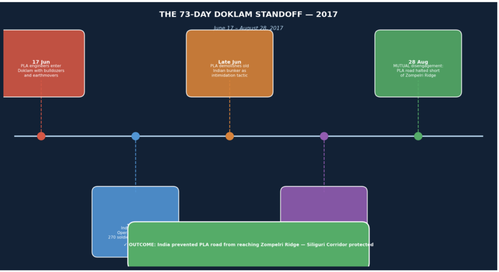
The Doklam standoff demonstrated how India countered Chinese grey-zone tactics at the LAC without escalating into conventional conflict. The decision to intervene was not taken lightly. India was essentially choosing to physically block a PLA engineering column on territory that China claims, using force on behalf of a third country, in an operation that could spiral into a shooting war at high altitude. On 18 June 2017, the Indian Army crossed the Sikkim border into Doklam.
What India did next was operationally elegant in its simplicity. Rather than deploying a large conventional force — which would have escalated optics and handed China a propaganda narrative, it sent approximately 270 armed soldiers with two bulldozers. The message was calibrated: match China’s machinery with machinery, China’s soldiers with soldiers. No more, no less.
The PLA responded with psychological counter-pressure: it demolished an old, non-operational Indian bunker near the standoff site, bulldozing it to rubble in a clear intimidation move. The Indian soldiers held their positions.
What followed was a 73-day test of institutional nerve. China issued sharp diplomatic protests, accused India of violating Chinese sovereignty, and brought up historical claims to the plateau. State media ran aggressive commentary about how India would “pay the price.” Chinese social media amplified footage of the bunker demolition. None of it moved the Indian line.
On 28 August 2017, both sides agreed to disengage. The precise terms were not fully disclosed, deliberate ambiguity that both sides found diplomatically useful, but the operational reality was clear: the PLA road had not reached the Zompelri Ridge. India’s line of sight over the Siliguri Corridor remained intact from that angle.
Doklam Standoff: Key Timeline
| Date | Event |
| 17 Jun 2017 | PLA engineering contingent enters Doklam with earthmovers; begins road construction toward Zompelri Ridge |
| 18 Jun 2017 | India launches Operation Juniper: ~270 armed troops + 2 bulldozers cross Sikkim border into Doklam |
| Late Jun 2017 | PLA demolishes old Indian bunker as intimidation tactic; 73-day high-altitude standoff begins |
| Jul–Aug 2017 | Diplomatic back-channel talks; China issues repeated media warnings; Indian forces hold position |
| 28 Aug 2017 | Mutual disengagement: PLA road halted short of Zompelri Ridge; India withdraws its blocking force |
| 2018–2023 | Satellite imagery reveals Chinese construction of 22 Xiaokang villages + road network in Amo Chu valley |
| 2024–present | PLA infrastructure now 7–8 km from Zompelri Ridge via the alternative valley route |
The Contest Continues: China’s Quiet Pivot After Doklam
Beijing, to its credit, did not simply try the same approach twice. The 2017 standoff revealed a key vulnerability: flat, open plateau terrain in full view of Indian positions is a difficult place to build covertly. So China looked for a different route to the same objective.
The Amo Chu or Torrsa River valley cuts deep into western Bhutanese territory. Unlike the open Doklam Plateau, it is steep-sided and largely invisible from Indian positions on the ridges above. Starting around 2018–19, commercial satellite imagery from companies like Planet Labs and Maxar began revealing a systematic construction campaign in this valley: a road-by-road, village-by-village advance toward the same Zompelri Ridge that India had blocked China from reaching in 2017.
By 2022, analysts at the Observer Research Foundation and western think-tanks had identified at least 22 new Xiaokang (‘moderately prosperous’) villages — including the now-widely discussed Pangda village — constructed inside what Bhutan claims as its own territory. These were not nomadic camps. They were permanent settlements with roads, administrative buildings, and what satellite imagery suggested were dual-use military logistics hubs.
The network of roads and tunnels associated with this construction has placed Chinese military infrastructure approximately 7 to 8 kilometres from the exact same Zompelri Ridge that India blocked in 2017 — approached from an angle and at a depth that makes direct Indian intervention far more complicated diplomatically. You can stop a single move. Stopping a strategy that simply routes around your stop is a different problem entirely.
“China did not abandon its Doklam objective. It simply found a new road to the same ridge.”
The Road That Changed Everything: DSDBO and India’s Northern Frontier
Eight hundred kilometres to the north-west of Doklam, a different kind of strategic competition was unfolding — one that would prove more consequential.
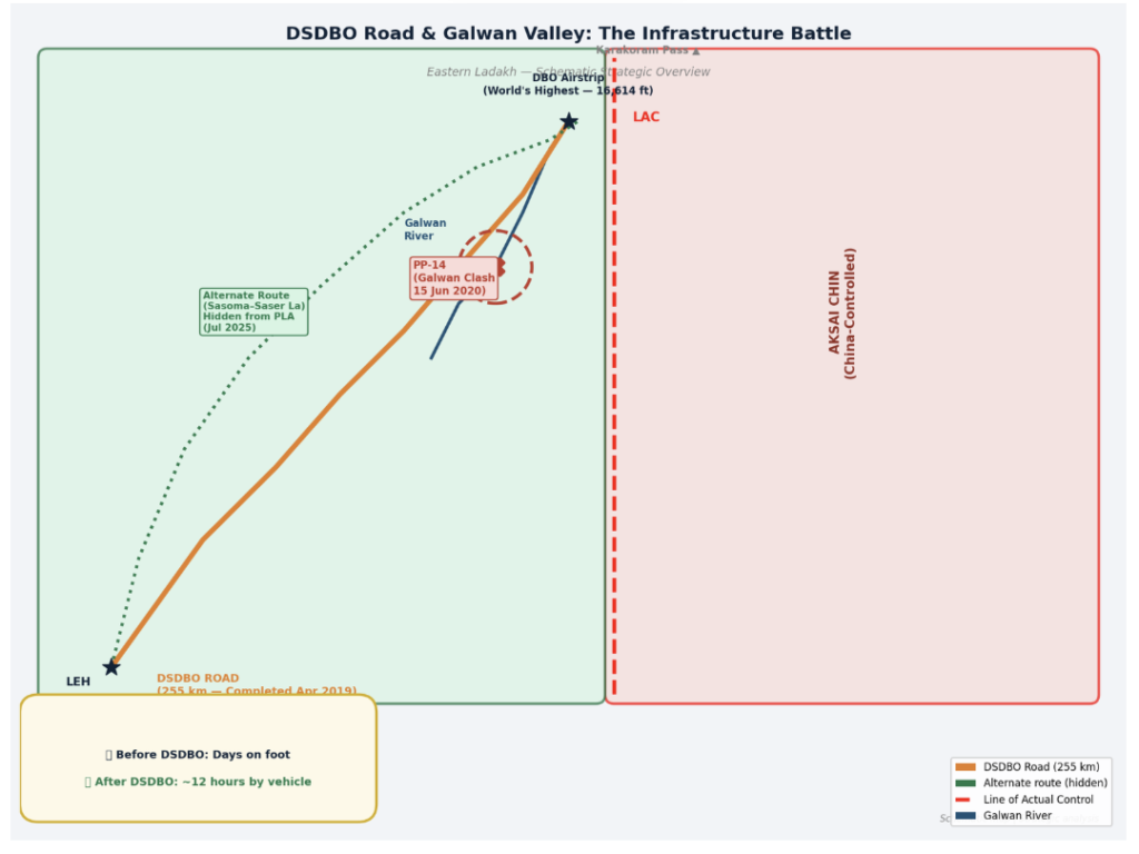
The Darbuk–Shyok–Daulat Beg Oldi (DSDBO) road is, in bald strategic terms, one of the most important pieces of infrastructure India has ever built. All 255 kilometres of it. Running parallel to the Line of Actual Control at altitudes consistently above 14,000 feet, it connects Leh — the regional military hub — to Daulat Beg Oldi, India’s northernmost military outpost beneath the Karakoram Pass. DBO also hosts the world’s highest advanced landing airstrip, capable of receiving military transport aircraft.
Before DSDBO, reaching DBO required days of gruelling foot marches through some of the world’s most hostile terrain. Supply lines were vulnerable to weather, distance, and Chinese interdiction. India completed the core DSDBO highway in April 2019. Travel time from Leh to DBO dropped from a multi-day ordeal to roughly 12 hours. Mechanised forces — trucks, artillery, armoured vehicles — could now reach the northern border in a single operational bound.
China noticed. Intelligence assessments cited by RUSI (Royal United Services Institute) and The Heritage Foundation note that the PLA’s military exercises in Tibet in early 2020 coincided almost precisely with India beginning to build lateral feeder roads and bridges from the DSDBO toward forward positions along the LAC. The most significant: a new bridge over the Galwan River, near Patrolling Point 14 — the precise location that would soon become infamous.
Galwan 2020: The Night India’s Soldiers Bled for a Road
In May 2020, the PLA diverted thousands of troops from military exercises in Tibet and marched them westward into the Galwan River basin. They crossed the mutually understood Line of Actual Control and established an observation post at Patrolling Point 14, the sharp bend where the narrow Galwan River valley opens toward the Shyok River and the DSDBO highway.
The geography here matters acutely. From PP-14, on high ridges overlooking the valley junction, Chinese observers had direct line-of-sight onto the newly constructed DSDBO. Artillery positioned there could interdict the road. China had placed, in operational terms, a gun at India’s strategic throat.
On 6 June 2020, Indian and Chinese military commanders held a flag meeting and agreed to a phased disengagement. The PLA committed to dismantling its observation post and withdrawing. It did not.
On the night of 15 June 2020, Colonel B. Santosh Babu, Commanding Officer of the 16 Bihar Regiment, led a patrol up to PP-14 to verify the Chinese withdrawal. They found the PLA not only still present but reinforced.
What happened next was brutal and legally constrained. A 1996 bilateral agreement explicitly bans the use of firearms and explosives within two kilometres of the LAC. So both sides fought with what they had: improvised clubs, iron rods wrapped in barbed wire, stones. In sub-zero temperatures, on narrow mountain ledges above a rushing river, hundreds of soldiers from two nuclear-armed nations fought hand-to-hand.
Colonel Santosh Babu and nineteen of his men died. China’s casualties were higher — western intelligence assessments and Russian state media put the figure at 35 to 45, though Beijing officially acknowledged only four. That discrepancy became its own diplomatic liability.The events of Galwan demonstrated that India countered Chinese grey-zone tactics at the LAC despite intense military pressure.
India’s Response: Finish the Road
The expected response to a violent confrontation of this magnitude would be a halt to provocative construction, a cooling-off period, face-saving gestures. India did the opposite.
Within weeks of the Galwan clash, the government flew in approximately 12,000 additional construction workers to the region. The army provided armed escorts. The BRO operated in shifts. The final bridges were laid and the black-topping of the DSDBO was completed. The road that China had gone to war to prevent was done.
A buffer zone was established around the immediate clash site, preventing either side from patrolling to that exact point. But this forced the PLA to withdraw its observation tents back into Chinese-controlled Aksai Chin. The ridge no longer had Chinese eyes on India’s highway.
Then India began planning a second, hidden road.
Galwan Confrontation: Detailed Timeline
| Date | Event |
| Apr 2019 | India completes core 255-km DSDBO road; all-season access to DBO airstrip secured |
| May 2020 | PLA diverts troops from Tibet exercise; crosses LAC; establishes camp at Patrolling Point 14 (PP-14) |
| 6 Jun 2020 | Corps Commander-level flag meeting; PLA agrees to disengage and vacate PP-14 |
| 15 Jun 2020 | Col. B. Santosh Babu leads patrol to verify PLA withdrawal; finds post reinforced, not vacated |
| 15 Jun 2020 (night) | Hand-to-hand clash at PP-14; India: 20 KIA; China: estimated 35–45 (official: 4) |
| Jun–Aug 2020 | India deploys 12,000 extra construction workers; DSDBO black-topping completed under armed escort |
| Feb 2021 | India-China disengage from Pangong Tso north and south banks |
| Sep 2022 | Gogra–Hot Springs (PP-15) disengagement completed and verified by both sides |
| 21 Oct 2024 | Landmark patrolling agreement on Depsang Bulge and Demchok; final 2020 friction points resolved |
| 23 Oct 2024 | PM Modi and President Xi meet at Kazan BRICS Summit; agree to rebuild bilateral ties |
| Nov 2024 | Indian patrolling resumes at Demchok; troops exchange sweets at multiple LAC points on Diwali |
| Jul 2025 | BRO confirms work on alternate Sasoma–Saser La DBO route — hidden from Chinese observation |
| Sep 2025 | PM Modi lays foundation stone of 1,748-km Arunachal Frontier Highway (NH-913); ₹4.73 billion |
| Apr 2026 | Frontier Highway reassigned to BRO and NHIDCL for accelerated delivery |
“No shots were fired at Galwan. Twenty Indian soldiers and an unknown but larger number of Chinese soldiers died anyway. That is what grey-zone warfare looks like when the grey zone runs out.”
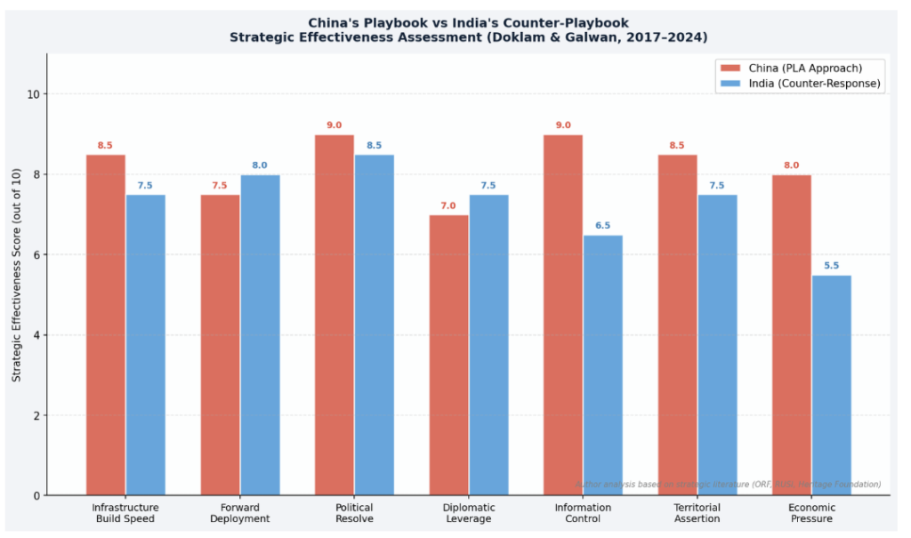
China’s Playbook vs India’s Counter-Playbook: A Direct Comparison
Stripped to their essentials, Doklam and Galwan reveal a remarkably consistent pattern on both sides. China probes with infrastructure and incremental encroachment; India responds with physical counter-presence and infrastructure acceleration. The table below captures this dynamic across multiple strategic dimensions.
| Dimension | China’s Approach | India’s Counter |
| Territorial Control | Road-building into disputed areas | Physical blockade — troops + bulldozers |
| Ambiguity Use | Claims grey zones as ‘historical territory’ | Forward patrolling to assert ground reality |
| Infrastructure | Highways, tunnels, Xiaokang villages | DSDBO road, Sela Tunnel, Frontier Highway |
| Psychological Ops | Bunker demolition, aggressive language | Hold ground; refuse to blink diplomatically |
| Salami Slicing | Incremental encroachment over decades | Symmetric deterrence — match each move |
| Information | Media blackout; deny casualties | Publicise builds; transparent infrastructure push |
| Alliance Factor | Pakistan (CPEC leverage) | Bhutan partnership (IMTRAT, DANTAK) |
The comparison reveals something important about India’s response. It was not simply reactive. By the time China arrived at Doklam with bulldozers, India already had IMTRAT in Bhutan and the Black Cats on the ridges above Chumbi. By the time China arrived at PP-14 to disrupt DSDBO, India was months from completing the road. Forward positioning — physical, infrastructural, and diplomatic — is what gave India the ability to respond with speed and credibility in both cases.
Five Lessons That Every Military Strategist Is Now Studying
Galwan further showed that India countered Chinese grey-zone tactics at the LAC through sustained strategic resolve. Doklam and Galwan have generated a cottage industry of strategic analysis. But the core lessons are fewer than the commentary suggests. Here are the five that matter most.Taken together, these lessons show how India countered Chinese grey-zone tactics at the LAC through infrastructure, deterrence and political resolve.
Lesson 1: Infrastructure Is Deterrence
The single most consequential lesson from both episodes is that a road can be as decisive as a tank regiment. China tried to stop DSDBO because DSDBO fundamentally shifted the mobility equation on India’s northern frontier. India stopped China at Doklam because it had pre-built the access infrastructure that allowed rapid intervention. India’s post-2020 infrastructure drive reflects this lesson at scale: the BRO’s budget expanded from around ₹3,200 crore in 2015 to approximately ₹16,000 crore in 2025. In December 2025 alone, Defence Minister Rajnath Singh inaugurated 125 critical strategic projects — 93 bridges and 28 roads.
Lesson 2: Early Intervention Shapes Permanent Facts
In 2017, India intervened when China had just arrived at Doklam with machinery. Had it waited — even for days — the diplomatic and military calculus would have been far more complex. Established facts on the ground carry enormous weight in territorial disputes. The post-Doklam construction in Amo Chu, executed quietly in deep valleys over several years, demonstrates exactly why early intervention is so disproportionately valuable. Once a road exists, contesting it requires challenging a civilian development project, not a military operation.
Lesson 3: Forward Presence Determines Diplomatic Outcomes
Both Doklam and Galwan were resolved through negotiation. But in both cases, the negotiated outcome was shaped by ground reality. At Doklam, India’s physical presence meant the PLA road could not reach the ridge; the disengagement froze the line before the strategic shift occurred. At Galwan, the buffer zone was established at a point that pushed the PLA back from its observation overlook of DSDBO. Nations that pre-position forces and infrastructure negotiate from strength; those that respond after the fact negotiate from disadvantage.
Lesson 4: Political Resolve Is a Military Asset
Military capability without political will is a liability. China has historically been adept at exploiting the gap between what adversaries can do and what their governments will authorise. At Doklam, India’s government held firm under extraordinary diplomatic pressure — explicit Chinese warnings about “paying the price” — for 73 days. After Galwan, despite twenty deaths and enormous domestic grief, the government accelerated construction rather than suspending it. That resolve sent a signal Beijing could calculate: India will not fold under pressure.
Lesson 5: Grey-Zone Aggression Requires Grey-Zone Responses
India’s most effective responses to Chinese grey-zone tactics were themselves grey-zone tools: roads, forward deployments, pre-positioned military training teams, infrastructure acceleration. Conventional military responses carry escalatory risks inappropriate for sub-threshold provocation. The hidden road to Daulat Beg Oldi via Sasoma and Saser La — confirmed in July 2025 — routes India’s strategic logistics entirely out of Chinese observation, defeating the surveillance advantage that makes PLA observation posts at PP-14 valuable. It does so without a single diplomatic statement or confrontational gesture.
India’s Border Infrastructure Build-Up: The Numbers Tell the Story
The most telling evidence that India has institutionalised the infrastructure-as-deterrence lesson is in the BRO’s own output data. Road construction accelerated sharply after 2019, took a brief dip during the COVID disruptions of 2020, and then surged to unprecedented levels. Budget allocations have more than quintupled since 2015.
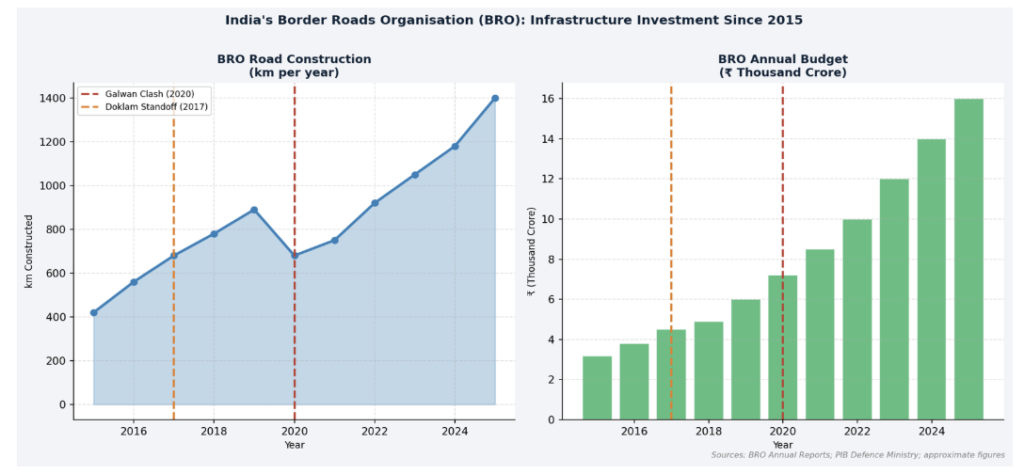
The 2023 Vibrant Villages Programme targets the depopulation problem in border areas, ensuring that frontier zones have permanent civilian infrastructure — connectivity, power, water — that complements military access. Because empty villages near the LAC are strategically vulnerable; populated ones are strategically anchoring.
Two projects stand out as transformative. The Sela Tunnel in Arunachal Pradesh — inaugurated in March 2024 — provides all-weather connectivity to Tawang valley at 13,000 feet, eliminating the seasonal road closure that previously left Indian forces isolated for months. And the alternate DBO route via Sasoma and Saser La reduces both distance and, more importantly, removes the road from Chinese ground-based observation entirely. That last point matters as much as the road itself.
Where Things Stand in 2026: Disengagement, Highways, and Unresolved Tensions
The October 2024 patrolling agreement was India’s most significant LAC diplomatic win since the Galwan clash. After 4.5 years of standoff, Indian and Chinese troops agreed to disengage from the last two remaining friction points — the Depsang Bulge and the Charding-Ninglung Nala junction near Demchok. By November 2024, patrolling had resumed, and in a widely-noted gesture, soldiers from both sides exchanged sweets at multiple LAC crossing points on Diwali.
The disengagement culminated in a Modi–Xi meeting at the Kazan BRICS Summit on 23 October 2024 — their first formal bilateral engagement since the breakdown of trust after Galwan. Both sides agreed to resume direct flights, reopen border trade routes, and ease visa procedures. Against the depth of the post-2020 estrangement, the rapprochement represented genuine diplomatic movement.
But the structural tensions remain, and they may have deepened in ways the patrolling agreement does not address. China’s military cooperation with Pakistan during Operation Sindoor in 2025 — including weapons supplies and what Indian security sources characterised as active intelligence sharing — exposed the two-front dimension of India’s security calculus in ways that no longer feel theoretical. Indian Army Chief General Upendra Dwivedi confirmed in January 2025 that India would not reduce troop deployments on the northern frontier.
On the infrastructure front, the pace has not slowed. The Arunachal Frontier Highway (NH-913) — 1,748 kilometres running parallel to the LAC from Tawang to Vijaynagar — is the most ambitious single project on India’s northern frontier. PM Modi laid its foundation stone in September 2025. China lodged immediate protests. In April 2026, the government reassigned the project from the state PWD to BRO and NHIDCL, signalling urgency.
Can Grey-Zone Aggression Be Deterred? The Ongoing Question
The honest answer is: partially, and at significant cost.
India stopped the Chinese road at Doklam in 2017. China simply found a different route and built it anyway, arriving at roughly the same strategic position seven years later through the Amo Chu valley, 22 villages, and a systematic land-absorption strategy executed under the political cover of “development.” India stopped the PLA from physically occupying the vantage point at Galwan’s PP-14. But a buffer zone is not a withdrawal — it is a managed standoff with costs to both sides’ patrol patterns. Ultimately, India countered Chinese grey-zone tactics at the LAC by combining border infrastructure, military preparedness and sustained diplomatic engagement.
What India has demonstrably achieved is the prevention of sudden, irreversible strategic shifts. The Zompelri Ridge did not get Chinese artillery in 2017. The DSDBO highway was completed despite violent opposition. DBO remains connected to Leh and its airstrip continues to operate. These are not small things. In territorial competition, preventing the rapid, irreversible loss of strategic advantage is often the best outcome available.
The broader deterrence question — whether sustained Indian resistance changes Chinese cost-benefit calculations and reduces the overall frequency and ambition of grey-zone probes — is less clear. China has not abandoned salami slicing. The Amo Chu construction, post-dating India’s tactical success at Doklam, is evidence that Beijing views individual setbacks as manageable within a longer strategic arc.
What has changed is India’s structural position. The country that could not move meaningful forces to DBO in winter before 2019 can now mobilise mechanised units within hours. The country with no all-weather road through Tawang valley is building a 1,748-kilometre frontier highway. The BRO that was once chronically underfunded operates with a ₹16,000 crore budget for 2025–26.
China’s grey-zone strategy works best against adversaries who are strategically unprepared, diplomatically isolated, and politically irresolute. India has spent the better part of a decade working on all three vulnerabilities. The infrastructure gap along the LAC — once so pronounced that Chinese planners could assume operational dominance — is narrowing, year by year, road by road.
None of this means the competition is over. The Yarlung Tsangpo mega-dam, the Xiaokang village network in western Bhutan, the China-Pakistan nexus made visible during Operation Sindoor: these are real, continuing pressures that a road or a buffer zone does not resolve. The 3,488-km LAC remains one of the world’s most active grey-zone theatres, and Beijing has demonstrated it has both the strategic patience and institutional capacity to pursue objectives across decades rather than news cycles.
But Doklam and Galwan have established something important in the strategic ledger: India can recognise what China is doing, absorb the pressure of a direct confrontation, respond with symmetric tools, and hold a position that matters. That is not classical deterrence. It is the steady, grinding work of making each incremental Chinese advance more costly than the last — and hoping, perhaps, that even Beijing has a price.
Frequently Asked Questions
The following questions address the most commonly searched queries related to India countering Chinese grey-zone tactics at the LAC, optimised for Google’s Featured Snippets and FAQPage structured data.
| Question | Answer |
| What is grey-zone warfare? | Grey-zone warfare sits below the threshold of conventional armed conflict. It uses infrastructure, demography, economic coercion, and calibrated military pressure to alter territorial facts without triggering a formal war. China’s road-building in disputed border areas is a textbook example. |
| Why did India intervene at Doklam if it is Bhutanese territory? | India intervened because the Chinese road, if completed to the Zompelri Ridge, would have allowed direct PLA observation and potential interdiction of the Siliguri Corridor — India’s only land link to its north-eastern states. Bhutan’s security is tied to India’s under the 1949 and 2007 bilateral friendship treaties. |
| How many soldiers died at Galwan? | India officially acknowledged 20 fatalities, including Colonel B. Santosh Babu (CO, 16 Bihar Regiment). China acknowledged only 4, but western intelligence and Russian state media estimated Chinese casualties at 35–45. The opacity became a diplomatic liability for Beijing. |
| Was the DSDBO road the trigger for Galwan? | Yes. India completed the DSDBO in April 2019 and then began lateral feeder roads toward the LAC, including a bridge over the Galwan River. The PLA mobilised from a Tibet exercise in May 2020 to disrupt this. Most analysts at RUSI and ORF identify Indian infrastructure progress as the proximate trigger. |
| What is the current LAC status in 2026? | Following the October 2024 patrolling agreement, all six 2020 friction points have been disengaged. But trust remains fragile: China’s military support to Pakistan during Operation Sindoor (2025), Yarlung Tsangpo dam construction, and ongoing Xiaokang village expansion in Bhutan continue to shape India’s elevated border posture. |
| What is the Xiaokang village strategy? | Beijing has built 600+ ‘moderately prosperous’ villages along its southern border since 2017, including 22+ inside disputed western Bhutanese territory in the Amo Chu valley. These establish civilian-demographic claims on disputed land while providing forward logistics for the PLA — harder to contest diplomatically than explicit military bases. |
| What is the Arunachal Frontier Highway? | NH-913 is a 1,748-km highway parallel to the LAC from Tawang to Vijaynagar, sanctioned at ₹28,229 crore (~$3.4 billion). PM Modi laid the foundation stone in September 2025. Reassigned to BRO and NHIDCL in April 2026 for faster delivery. It will enable rapid lateral troop movement across all five Arunachal valleys. |
| What is India’s alternate DBO route? | India is building a second road to Daulat Beg Oldi via Sasoma and Saser La, running through deep valleys entirely shielded from Chinese ground observation. Confirmed by multiple sources in July 2025, it cuts 79 km off the existing DSDBO distance and eliminates the Chinese surveillance advantage over India’s northern logistics. |
External Authority Links & Sources
- Observer Research Foundation (ORF): https://www.orfonline.org — India’s premier strategic think-tank; ORF Occasional Paper No. 508 (Nov 2025) on post-Galwan India-China strategy.
- Ministry of Defence — BRO : https://bro.gov.in — Official source for BRO construction data, project maps, and budget figures.
- RUSI (Royal United Services Institute): https://www.rusi.org — RUSI 2020 commentary on Galwan provides authoritative infrastructure-as-deterrence analysis.
- Press Information Bureau — Defence: https://pib.gov.in — Official GoI press releases on BRO project inaugurations including December 2025 (93 bridges, 28 roads).
- The Heritage Foundation: https://www.heritage.org — Analysis of how India’s infrastructure posture resists Chinese coercive tactics at the LAC.
- Indo-Pacific Defense Forum: https://ipdefenseforum.com — January 2026 analysis of the infrastructure arms race along the India-China border.
- NewsonAIR (Govt. of India): https://www.newsonair.gov.in — Official coverage of Depsang-Demchok disengagement (October–November 2024)

One thought on “How India Countered China’s Grey-Zone Tactics at the LAC | Doklam, Galwan & Border Strategy”