China satellite images Pakistan analysis gained global attention when a Shanghai-based geospatial intelligence firm released detailed imagery of Noor Khan Airbase.A Chinese geospatial firm’s satellite imagery reveals Pakistan hardening its bases post-Operation Sindoor — exposing the fragile edges of an all-weather alliance, demonstrating Chinese ISR dominance over South Asia, and prefiguring the future of space-enabled warfare in one of the world’s most volatile regions.
1. The Images That Were Never Supposed to Be Public
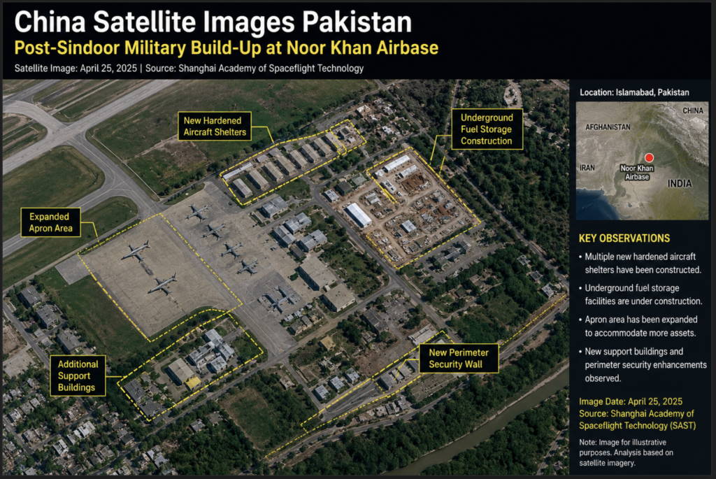
Sometime in mid-2025, a Shanghai-based geospatial intelligence firm published satellite images of Noor Khan Airbase — one of Pakistan’s most sensitive military installations. The images didn’t leak. They were published deliberately, annotated with AI-generated labels, and distributed through commercial intelligence channels that feed think tanks, newsrooms, and government assessment units from New Delhi to Washington.
The firm behind the release, MizarVision, framed the imagery as routine commercial analysis. Most regional defence observers weren’t buying that characterisation for a moment.The China satellite images Pakistan disclosure quickly attracted attention among defence analysts and OSINT researchers.
The timing was not coincidental. Noor Khan had been struck during India’s Operation Sindoor in May 2025 — a campaign of precision strikes against Pakistani military infrastructure that produced visible damage across at least three major air bases. The satellite imagery, corroborated by independent open-source intelligence (OSINT) analysts using commercial platforms, showed a Pakistani military in active reconstruction mode. Runways repaired. Shelters reinforced. Aircraft parking dispersed. New structures rising from freshly poured concrete.
A Chinese company had effectively handed the world a detailed battle damage assessment — and a live progress report — on Pakistan’s most critical air logistics hub. The publication raised a question that defence analysts were still debating weeks later: was this accident, commercial opportunism, or a calculated message from Beijing to its ostensible ally?
2. Who Is MizarVision? The Company Behind the Imagery
MizarVision is not a household name even inside China’s growing commercial space sector, which makes its sudden prominence in the South Asian security debate more interesting rather than less.
Founded in Shanghai, the company sits within a loosely regulated but strategically significant grey zone that characterises much of China’s commercial imaging industry. Its public-facing work covers urban planning analysis, agricultural assessment, and environmental monitoring — the kind of portfolio that defines legitimate commercial remote sensing worldwide. But the company’s satellite constellation operates at sub-metre resolution, with publicly available specifications suggesting imagery capture at approximately 50 centimetres or better. At that resolution, analysts can identify aircraft types on aprons, assess construction material signatures on new structures, and measure the dimensions of blast damage.
Ownership and State Relationships
MizarVision’s ownership structure is not publicly disclosed in detail, which is itself consistent with the broader pattern of Chinese technology firms where state-adjacent investment vehicles and venture capital from state-owned enterprises blend in ways that make clear attribution difficult. Under China’s 2017 National Intelligence Law, domestic companies can be compelled to provide data to state authorities upon request.
Several analysts studying China’s space sector have noted that the boundary between commercial imaging firms and the PLA’s Strategic Support Force — the branch responsible for space, cyber, and information warfare — is considerably thinner than corporate branding suggests.
MizarVision’s imagery uses optical sensors, meaning the released images are standard visual-spectrum captures rather than synthetic aperture radar (SAR). Optical imagery is weather- and daylight-dependent, which SAR is not, but at 50 cm resolution it provides considerably more visual detail than SAR imagery at equivalent cost. The AI annotation layer — automated labels flagging infrastructure types, impact zones, and construction stages — is processed through machine learning pipelines trained on large imagery libraries, almost certainly including military and dual-use infrastructure across Asia.
Independent Verification
Independent OSINT analysts cross-referenced the MizarVision imagery against commercial captures from Planet Labs and Maxar taken around the same period. Several structural features — new hangar outlines, resurfaced taxiways, dispersed apron configurations — appeared consistent across multiple imaging sources from different sensor operators. The AI-generated annotations flagging specific impact craters and reconstruction zones also aligned with details already in the public record from India’s strike campaign.
The confidence level of the AI annotations, however, is harder to assess independently. Object detection models can misclassify construction materials, confuse blast damage with routine maintenance, and flag temporary installations as permanent hardening. Analysts across multiple institutions cautioned that claims about polymer or radar-absorbent coating applications — among the more specific annotations in the MizarVision release — should be treated as assessments pending ground verification rather than confirmed findings.
3. China Satellite Images Pakistan: What the Satellite Imagery Shows
The released imagery covers several distinct features at Noor Khan Airbase and the separate naval vessels photographed at Colombo port in June 2026. At Noor Khan, the most visually prominent features are new hardened aircraft shelters estimated at 50 to 70 metres in length — structures large enough to accommodate Pakistan Air Force heavy transport aircraft and, based on dimensional analysis, the IL-78 tanker fleet.
Sections of the main runway show fresh resurfacing visible as tonal contrasts in the optical frames. Impact crater fill-and-compact sequences are visible at two points along the runway centreline and one section of the parallel taxiway, consistent with reported cratering from India’s precision munitions. Fuel storage infrastructure appears partially redistributed, with newer bermed tank configurations placed further from the flight line than pre-strike baseline imagery suggests was previously the case — implying deliberate dispersal to reduce cascade damage in any future strike.
Most analytically interesting — and most difficult to independently verify — are the annotations suggesting special-material coating applications on selected hangar rooftops. Such treatments, sometimes described as radar-absorbent materials (RAM) or thermal signature management coatings, have precedent in Chinese airbase construction doctrine. If accurate, it suggests Pakistan is importing hardening techniques directly from its primary arms supplier’s engineering playbook. If the AI detection algorithms have overreached on spectral anomalies that have a mundane explanation — weatherproofing, solar paint, routine roofing treatments — the significance shrinks considerably.
4. Operation Sindoor — A Compressed Timeline of India’s Precision Strikes
The events that lent the MizarVision imagery its strategic significance trace back to the night of 6–7 May 2025, when India launched what it described as a targeted counter-terrorism campaign against militant infrastructure in Pakistan and Pakistan-Administered Kashmir.
The Triggering Event
The triggering event was the April 22, 2025 massacre of tourists at Pahalgam in Indian-administered Kashmir. Twenty-six civilians — primarily Hindu pilgrims — were killed in a coordinated attack. Indian intelligence attributed the assault to The Resistance Front, assessed as a proxy of Lashkar-e-Taiba. Pakistan denied involvement or foreknowledge.
Sequence of Strikes
India’s military response, codenamed Operation Sindoor, unfolded across approximately 90 minutes using stand-off precision munitions, air-launched cruise missiles, and loitering munitions — weapons designed to loiter over target areas before diving onto specific points. Initial strikes targeted nine locations across Pakistan and Pakistan-Administered Kashmir, hitting infrastructure described by India’s Ministry of Defence as militant training camps, command nodes, and logistics hubs. Pakistani military airbases were struck in what India characterised as responses to Pakistani retaliatory actions rather than initial targeting.
Bases Targeted
Noor Khan Airbase near Rawalpindi was among confirmed strike locations. So were Jacobabad (PAF Base Shahbaz) and Bholari, two forward operating bases in Sindh province that provide Pakistan Air Force rapid deployment capacity toward the Indian border. Reporting from multiple independent sources, including assessments from US and European commercial satellite operators, confirmed runway damage at Noor Khan and significant blast effects at infrastructure facilities at Jacobabad.
Weapons Employed
India’s strike package reportedly included SCALP/Storm Shadow cruise missiles, BrahMos supersonic cruise missiles, SPICE-series precision-guided bombs adapted for runway cratering, and loitering munitions — sometimes described in post-strike Indian briefings as ‘kamikaze drones’ for their single-use attack profile. The combination of stand-off weapons and loitering munitions complicated Pakistani interception attempts by creating simultaneous, multi-axis engagements at different altitudes and speeds.
Battle Damage Assessment
India claimed successful disruption of specific Pakistani Air Force operational capacity through runway denial and infrastructure damage. Pakistan acknowledged strikes on its territory but disputed their characterisation as counter-terrorism operations, framing the attacks as unprovoked aggression and claiming its air defences intercepted a significant fraction of incoming weapons. Independent satellite imagery taken in the days following the strikes showed visible damage at multiple facilities consistent with India’s claims, though the full extent of Pakistani losses remained disputed in publicly available information.
A fragile ceasefire was brokered around May 18, 2025, reportedly with significant American diplomatic pressure. The reconstruction visible in subsequent satellite imagery was, by any analysis, substantial enough to validate that something significant had been damaged.
5. Why Noor Khan Airbase Is Unlike Any Other in Pakistan
PAF Base Nur Khan — better known as Noor Khan — sits at Chaklala, a suburb of Rawalpindi, approximately one kilometre from the Rawalpindi Cantonment and roughly 12 kilometres from Islamabad’s diplomatic and governmental core. That geography alone distinguishes it from every other military airfield in Pakistan. This is not a forward combat base. This is command country.
Strategic Role
Noor Khan hosts Pakistan Air Force Air Transport Command, the unit responsible for strategic airlift, aerial refuelling, and VIP transport. The IL-78 Midas tanker fleet — Pakistan’s primary aerial refuelling aircraft, acquired from Ukraine in the early 2000s — operates from this base, making it a force multiplier for the entire PAF fighter complement. Any aircraft needing extended range, extended mission time, or multi-sortie capacity on a given day needs those tankers. And the tankers operate from Noor Khan.
C-130 Hercules transport aircraft for rapid force deployment, humanitarian operations, and special operations insertion are also resident. The aircraft ferrying Pakistan’s senior military and political leadership — Prime Minister transport, Chief of Army Staff transport, inter-service coordination flights — depart from Noor Khan. Damage to this base during wartime is not just tactical; it is a disruption to the command and logistics nervous system that keeps the rest of Pakistan’s military coherent.
Why India Targeted It
India was not simply hitting a combat squadron at Noor Khan. It was demonstrating an ability to reach the administrative and logistical heartland of Pakistan’s military command structure — within surveillance range of General Headquarters Rawalpindi, within driving distance of the National Command Authority’s decision-making centres. The message was direct rather than subtle, and it was clearly received, given the scale of reconstruction subsequently visible from orbit.
The post-strike hardening now underway at Noor Khan is designed primarily to protect the logistical backbone — tankers, transports, command connectors — rather than combat aircraft. These assets cannot be easily dispersed to forward bases in a crisis because their role is inherently centralised. Protecting them against a future Sindoor-style strike appears to be the driving logic behind the construction visible in MizarVision’s imagery.
6. The Doctrine and Science of Airbase Hardening
The conceptual basis for protecting aircraft from airbase attack predates precision munitions by several decades. Israel’s experience in June 1967, when Arab air forces were destroyed on the ground in the opening hours of the Six-Day War, crystallised the fundamental calculus: an aircraft exposed on an open apron during a strike is permanently gone; the same aircraft in a hardened shelter might survive intact, flyable, and ready for the next sortie.
Historical Development
That lesson drove the construction of hardened aircraft shelters across NATO airbases throughout the Cold War, particularly in West Germany, where Soviet deep-strike doctrine made dispersal and hardening operational necessities rather than precautions. Standard Cold War-era NATO HAS structures used reinforced concrete several feet thick with earth berming on exterior faces to absorb blast energy. Interior aircraft were protected against everything except a direct munitions hit.
Israel has pushed airbase survivability further than most states, with extensive underground infrastructure at key facilities including tunnels, hardened parking, and subsurface fuel storage. Iran, working around international sanctions that limit construction technology access, has carved aircraft parking tunnels directly into mountain rock faces.
Taiwan’s Chiashan airbase in Hualien County represents perhaps the world’s most extreme hardening: PAF F-16s and support aircraft operate from underground hangars accessible only through tunnelled rock entrances, providing near-absolute protection from conventional air attack.
China’s own PLAAF airfields have seen significant hardening investment across the past decade. Semi-buried reinforced concrete shelters are visible at numerous bases in eastern China on commercial satellite imagery. Given that Beijing is Islamabad’s primary defence technology supplier, it is reasonable to assess that the hardening doctrine now being applied at Pakistani facilities draws directly from Chinese military engineering practice and doctrine.
Specific Measures Visible in Pakistan
The post-Sindoor reconstruction programme at Pakistani bases, based on available satellite analysis, incorporates several distinct hardening approaches. Blast-resistant hangar doors, reinforced concrete aprons, earth-bermed revetments, and dispersed aircraft parking are conventional measures. Underground fuel storage migration — moving fuel reserves from surface tanks to partially buried configurations — reduces cascade damage risk from secondary explosions. Runway repair pre-positioning (keeping repair kits and rapid-fill materials stored at strategic points along the runway) reduces the time needed to reopen a cratered surface for operations.
The polymer or special-material coating applications annotated on certain Noor Khan structures, if confirmed, represent a more sophisticated measure drawn from Chinese airfield construction approaches. Radar-absorbent materials reduce the electromagnetic signature of large metallic structures against imaging radars and ground-mapping systems — not a primary defence against precision strike weapons, but a potential complication for SAR-based targeting.
7. China’s Eye in the Sky — ISR Architecture Over South Asia
China has built, over the past fifteen years, one of the world’s most comprehensive space-based intelligence, surveillance, and reconnaissance architectures. That architecture covers South Asia continuously. The China satellite images Pakistan case highlights the growing reach of Beijing’s satellite surveillance architecture.
Military Constellations
The Yaogan series — China’s primary military reconnaissance satellite constellation — includes optical, synthetic aperture radar (SAR), and electronic intelligence (ELINT) variants. Optical Yaogan satellites are assessed by Western intelligence agencies as capable of sub-50-centimetre resolution, placing them in the same class as US KeyHole imaging systems. SAR variants penetrate cloud cover and operate at night, removing the weather and daylight constraints that limit optical platforms. ELINT variants harvest radar emissions and communications intercepts from ground-based military systems.
The Gaofen series, officially designated civilian, operates at resolutions between 0.5 and 2 metres across multiple spectral bands. Gaofen-6 added wide-swath imaging capacity that significantly increased the terrain coverage achievable in a single pass. Several later Gaofen satellites have pushed optical resolution to sub-metre levels comparable to leading US commercial competitors.
Commercial Layering
Commercial constellations operated by firms including MizarVision, SuperView, and Chang Guang Satellite Technology Company operate alongside state systems, creating a layered architecture where commercial and military sensors reinforce each other. Under China’s national security law, these firms share data with state authorities on request. Ground processing infrastructure for commercial and military imagery is, in several documented cases, shared or co-located.
The practical revisit rate over a specific high-priority target like Noor Khan, combining state and commercial assets, likely exceeds several passes per day — sufficient for near-continuous monitoring of construction activity, aircraft movements, and operational patterns. Beijing doesn’t just know what Islamabad is building post-Sindoor. It knows the sequence, the pace, the priorities. Whether that intelligence is shared with Pakistan’s adversaries, held exclusively within Chinese analytical systems, or selectively released through commercial vehicles like the MizarVision publication is a question of intent that China controls entirely.
8. What AI Is Actually Doing to Geospatial Intelligence
The MizarVision imagery release was notable not only for what was captured but for how it was processed and presented. The annotations visible in the released frames — labels flagging infrastructure types, impact points, and construction stage classifications — are products of automated machine-learning pipelines rather than traditional photo-interpreter analysis. That distinction matters more than it might seem.
Core AI Capabilities in Imagery Analysis
AI-powered geospatial analysis has, over the past five years, dramatically transformed the economics of imagery intelligence. What previously required a team of trained analysts working over hours or days can now be processed across thousands of satellite frames simultaneously, at machine speed. Specific capabilities include change detection (identifying what has changed between a baseline image and a current capture, automatically flagging new structures or alterations); object classification (identifying whether a structure is a hardened aircraft shelter, an ammunition storage facility, or a maintenance hangar based on shape, shadow length, and spectral signatures); damage assessment (quantifying blast damage from impact crater morphology and structural deformation patterns); and target geolocation (pinpointing coordinates of specific features with sufficient precision for targeting or retargeting purposes).
Military Significance
For defence planners, this capability shift represents a fundamental acceleration of the intelligence cycle. Information that previously required days to process and distribute through classified channels now completes its analytical cycle in hours and can be published commercially. Crucially, that speed advantage no longer requires a superpower’s classified satellite fleet and cleared analyst workforce. It can be built on commercial imagery processed with publicly available or commercially licensed AI tools — a development with profound implications for the range of actors who can now conduct credible imagery intelligence.
The Autonomous Kill Chain Trajectory
The military implications extend beyond assessment toward autonomous engagement architectures. Combining high-revisit commercial imaging with AI-based target recognition and precision strike weapons creates the theoretical framework for sensor-to-shooter cycles where human intervention in the assessment stage is minimised. China’s military doctrine — particularly as articulated in PLA publications on ‘intelligentised warfare’ — explicitly anticipates this trajectory as the defining feature of near-future conflict. For Pakistan, the immediate practical implication is that whatever it constructs at Noor Khan is being processed in near-real time by the same country supplying the construction doctrine. The recursive quality of that arrangement is unusual in any alliance context.
9. The China-Pakistan Military Alliance — Four Decades of Integration
The defence relationship between Beijing and Islamabad has its modern foundations in the early 1980s, when China became a primary source of weapons and technology for Pakistan following US sanctions over Islamabad’s nuclear programme. What began as a relationship of convenience — China providing arms that the US would not, Pakistan providing geopolitical balance against Soviet Afghanistan — has evolved into the most comprehensive bilateral military-industrial partnership in South Asia.
Combat Aircraft Programmes
The JF-17 Thunder — a joint development between Pakistan Aeronautical Complex and China’s Chengdu Aircraft Corporation — began formal development in 1999 and has delivered more than 100 aircraft across successive blocks, with Block III variants incorporating AESA radar and significantly upgraded avionics. The aircraft is simultaneously Pakistan’s most numerous combat platform and one of China’s most visible defence export successes, actively marketed to third-country customers from Southeast Asia to Africa.
Pakistan’s acquisition of J-10C fighters marked a more significant technology transfer threshold. The J-10C is an air-superiority platform comparable in generation to late-model F-16 variants. Deliveries began in 2022, with initial batches reportedly including the PL-15 extended-range air-to-air missile — one of the most capable beyond-visual-range weapons in any export inventory. Pakistani J-10Cs were reportedly active during the post-Sindoor period.
Naval Integration
Naval integration has been equally comprehensive. Eight Hangor-class submarines — based on China’s Type 039B Yuan-class design — were contracted in 2015 under a programme involving construction at Karachi Shipyard with extensive Chinese technical assistance. The frigates PNS Taimur and PNS Aslat are Jiangkai II (Type 054A/P) derivatives built in China. Pakistan’s long-range air defence network incorporates the HQ-9P surface-to-air missile system. China also provides satellite communications infrastructure through agreements covering Pakistan’s PAKSAT constellation.
The CPEC Dimension and Dependency Calculus
The economic dimension through CPEC — the China-Pakistan Economic Corridor — has deepened strategic integration further. Billions in Chinese-financed infrastructure create debt relationships that structurally constrain Islamabad’s ability to distance itself from Beijing without facing significant economic consequences. Defence financing through concessional lending for Chinese platforms adds a separate layer of dependency.
Compared to Pakistan’s other defence relationships, the depth of Chinese integration is striking. The US was Pakistan’s primary arms supplier through the Cold War and post-9/11 period, but the relationship deteriorated sharply after 2011 and collapsed almost entirely under the pressures of the 2010s. Turkey supplies drones and has provided some frigates but doesn’t approach Chinese scale or technology depth. Gulf states provide finance and diplomatic support rather than defence-industrial substance. China is now, by a considerable margin, Pakistan’s most important and least replaceable defence partner — a dependency with obvious implications for how Islamabad can respond to Beijing’s actions.
10. Six Competing Interpretations of China’s Disclosure
The most analytically important question raised by the MizarVision publication is not what the imagery shows but why it was released. Defence analysts have offered competing frameworks, none of which is individually conclusive and several of which can operate simultaneously.
Interpretation One: Beijing Warning Islamabad
Pakistan has, since 2024, made several quiet overtures toward US re-engagement — contacts around potential drone acquisition, financial discussions requiring American goodwill, diplomatic signalling that complicated Beijing’s preferred narrative of clean Pakistani alignment. Beijing reportedly views these manoeuvres with suspicion. Publishing detailed imagery of Pakistani military vulnerabilities under a commercial banner is, on this reading, a pointed message: we see everything, we know what you damaged and what you’re rebuilding, and we control the narrative about your military effectiveness.
Interpretation Two: Commercial OSINT Publication
A more prosaic reading is that MizarVision published the imagery for commercial demonstration purposes. Satellite imaging firms compete on resolution, AI processing speed, and the ability to capture newsworthy events rapidly. Post-conflict zone imagery of visible military activity is, in commercial terms, exactly the material that drives subscriptions and investor attention. The Noor Khan imagery, on this reading, is a geospatial equivalent of a news photograph — published because it’s compelling and commercially valuable.
Interpretation Three: Defence Export Marketing
China sells military systems to dozens of countries. Demonstrating that Chinese satellite intelligence can monitor, annotate, and assess those systems’ operational environments in near-real time is extraordinarily effective marketing. The imagery publication simultaneously advertises two product lines: the Chinese-supplied platforms visible in the hangars being protected, and the Chinese ISR capability monitoring those platforms. Potential customers in the Middle East, Southeast Asia, and Africa are watching.
Interpretation Four: Strategic Messaging to India
New Delhi’s intelligence community represents a plausible secondary audience. By revealing Pakistani reconstruction details at Noor Khan, Beijing demonstrates it holds detailed, current, AI-processed intelligence on Pakistani military adaptation — information of obvious relevance to any future Indian targeting cycle. The implicit message to India: we know what you hit, we know what they’re rebuilding, and we’re watching both of you with capabilities you can’t fully replicate.
Interpretation Five: Normalising Chinese Surveillance Power
By publishing high-resolution military imagery of an allied state’s facilities under commercial branding, China normalises comprehensive satellite surveillance as an ordinary commercial activity. This blurs the distinction between state intelligence and commercial monitoring — a distinction China benefits from eroding as it accelerates its own ISR capabilities and seeks to establish norms around surveillance that align with its interests rather than Western conceptions of intelligence restraint.
Interpretation Six: Plausible Deniability Architecture
Pakistan’s air defences — supplied substantially by China — failed to intercept Indian strike packages during Operation Sindoor. Rather than acknowledging system failures, Beijing may be establishing a record attributing vulnerability to Pakistani operational practices rather than Chinese technology. The imagery creates a documented timeline: what wasn’t protected before the strikes, what Pakistan is now fixing, implying that the damage resulted from Pakistani decisions rather than Chinese equipment failures. This serves Beijing’s defence export reputation regardless of what actually caused the losses.
11. Submarines in Colombo — The Naval Dimension
The June 2026 satellite images of Pakistani naval vessels at Colombo port deserve separate analysis, because submarines and surface warships present fundamentally different vulnerability calculations in an intelligence environment.
The Hangor-Class Submarine Programme
The Hangor-class submarine programme — Pakistan’s most significant naval capability acquisition in decades — involves eight boats contracted under a technology transfer arrangement with China Shipbuilding Industry Corporation signed in 2015. The first unit, PNS Hangor — named for the submarine that sank INS Khukri in 1971, Pakistan’s most celebrated naval engagement — was reportedly commissioned in late 2023. The boats are based on the Chinese Type 039B Yuan-class design, a conventionally powered vessel equipped with air-independent propulsion (AIP) that significantly extends submerged endurance over older diesel-electric designs.
For the Indian Navy, AIP-equipped conventional submarines represent a meaningful capability escalation. These vessels are considerably quieter than older diesel-electric boats and can remain submerged without snorkelling for substantially longer durations, complicating the anti-submarine warfare (ASW) problem significantly. India’s ASW capabilities have been improving but would face genuine challenges tracking well-handled Pakistani AIP submarines in the contested littoral and deep-water environments of the Arabian Sea and the approaches to Gujarat and the Kathiawar Peninsula.
Why Colombo Exposure Is Problematic
Submarines derive their military value almost entirely from positional uncertainty. An adversary who cannot locate a submarine must assume it could be anywhere in a given operational area — a powerful deterrent effect. An adversary who has just seen satellite imagery of that submarine docked in Colombo on a specific date, annotated by a Chinese geospatial firm, now has information about deployment patterns, crew rotation indicators, and foreign port access arrangements that degrades that positional uncertainty considerably.
Pakistan’s goodwill visit to Colombo was pre-planned and publicly announced as a diplomatic gesture. The submarine’s participation in what is conventionally a surface ship diplomatic exercise suggests Islamabad wanted to display the asset to regional partners — perhaps to signal capability to Sri Lankan naval officials or to regional observers monitoring Indian Ocean balance. The satellite documentation of that display by a Chinese commercial firm adds an exposure layer that Pakistani naval planners likely did not anticipate, or chose to accept as the price of the diplomatic signalling.
Sri Lanka and Indian Ocean Competition
Sri Lanka’s position in this dynamic is quietly significant. Colombo’s port has been a focal point of Indian Ocean competition between China and India for years. Pakistani naval access to Colombo facilities, documented in Chinese satellite imagery and commercially published, carries information about basing patterns and strategic relationships that regional powers have noted. It is not a development India’s Integrated Defence Staff is likely to have filed without comment.
12. What This Changes for India, Pakistan, and the Region
For India
For Indian defence planners, the MizarVision imagery release is, paradoxically, operationally useful. India now has Chinese commercial documentation of Noor Khan’s reconstruction — structural dimensions, blast protection configurations, apparent attempts at radar signature reduction — available through open channels. The imagery also validates India’s own strike effectiveness assessments. The scale of reconstruction confirms that the damage was significant enough to prompt a major engineering response.
More strategically, the Chinese surveillance disclosure reveals a competitive dynamic: Beijing is maintaining near-real-time coverage of both Pakistani adaptation and implicitly of Indian targeting implications. India’s own ISR capacity in the theatre, while improving through indigenous satellite programmes and agreements with allied nations, does not yet match the combined state-commercial architecture China has deployed.
For Pakistan
The dynamics for Islamabad are considerably more uncomfortable. The disclosure demonstrates that Pakistan’s principal ally maintains comprehensive surveillance of its military installations and is willing to publish that surveillance commercially under cover of a nominally private firm. Pakistan’s ability to pursue quiet military adaptation — to harden bases, reposition assets, repair damaged infrastructure — is constrained by the knowledge that its most important defence partner is watching from orbit in near-real time, and publishing what it sees.
The dependency problem has an additional dimension: Pakistan cannot meaningfully retaliate against Chinese information disclosures without rupturing a relationship it cannot afford to lose. This creates an asymmetric power dynamic that Beijing can exploit selectively without significant consequences.
For the Wider Region
For South Asia’s security environment, the episode accelerates a trend already visible in the Ukraine war and the Gaza conflict: commercial satellite intelligence is becoming a standard feature of conflict, available to non-state actors, journalists, think tanks, and foreign governments alike. The democratisation of ISR changes the information environment within which wars are fought — and the political calculations of escalation and restraint that precede and follow them.
The MizarVision case adds a specifically state-adjacent dimension to that democratisation, where curated commercial disclosure becomes an instrument of strategic communication. For regional security planners, the China satellite images Pakistan episode demonstrates how commercial ISR is reshaping military transparency.
13. Information Warfare in the Open-Source Intelligence Age
Before 2015, imagery of the quality published by MizarVision would have been accessible to perhaps a dozen governments with mature and expensive intelligence programmes. By 2025, comparable imagery is commercially available, AI-processed, and publishable by a Shanghai firm with a press release and a subscription service. The barriers that made satellite intelligence a superpower exclusive have largely dissolved.
The MizarVision episode adds a specific variant to this broader trend: curated commercial disclosure, where a state-adjacent entity publishes specific imagery targeting specific facilities at a specific time for reasons that align with state interests while maintaining commercial deniability. This category is distinct from genuine commercial OSINT (where publication decisions are market-driven), from intelligence leaks (which involve unauthorised disclosure), and from official government statements (which carry diplomatic weight and accountability).
Curated commercial disclosure occupies a grey zone that states with robust commercial satellite ecosystems can exploit with minimal risk. The publishing entity claims commercial motivation. The state claims no involvement. The intelligence effect is achieved regardless. For governments without equivalent commercial satellite infrastructure — which describes most of the world — there is no obvious mechanism to prevent or counter this kind of disclosure.
Pakistan’s situation illustrates the constraints most clearly. It cannot request that Beijing suppress commercially published imagery of Pakistani military facilities without implicitly acknowledging that the imagery reveals sensitive information. It cannot develop a counter-narrative around the imagery’s reliability without drawing more attention to the specific features the imagery documents. The optimal response is silence, which is itself a form of concession.
14. Global Precedents — Ukraine, Israel, Taiwan, and the US Commercial Ecosystem
Ukraine: The Commercial Satellite War
The Ukraine conflict normalised commercial satellite intelligence as a primary tool of open-source conflict documentation. Maxar Technologies published imagery of Russian armoured columns stalled north of Kyiv in the early weeks of the 2022 invasion — images that shaped international media coverage and arguably the information battle in ways the Russian military had not anticipated. Planet Labs’ Dove constellation provided continuous monitoring of Russian military positioning at revisit rates that fundamentally changed what commercial imagery could show.
Capella Space’s SAR imagery penetrated cloud cover and darkness to document activities at Russian bases during conditions that would have rendered optical systems blind. Ukraine’s military, and the governments supporting it, incorporated commercial imagery into operational planning at a scale without precedent.
Israel-Iran: Mutual Surveillance
In the Israel-Iran confrontation of 2024–2025, Israeli strikes on Iranian military facilities and Iranian drone attack preparations were documented in commercial imagery that allowed analysts to assess attack packages and effects before official statements were released. The monitoring of Iranian airbase activity became routine commercial OSINT work, with the imagery published and analysed within hours of strikes. The dynamic worked in both directions: Iranian monitoring of Israeli facilities, through aligned commercial providers, created a roughly symmetrical surveillance environment neither side could fully escape.
Taiwan: The Chinese Commercial Precedent
The Taiwan Strait presents perhaps the most directly analogous precedent to the Pakistan case. Chinese commercial firms have published imagery of Taiwanese military facilities — including the Chiashan underground base — with a specificity and frequency that exceeds routine commercial interest, as documented by researchers tracking Chinese open-source intelligence publication patterns. Taiwanese military analysts have noted this as a deliberate capability demonstration directed at Taipei’s defence planning community.
US Commercial Firms and Regulatory Constraints
US commercial firms — Maxar, Planet Labs, BlackSky, Capella Space — operate within a regulatory framework under the Land Remote Sensing Policy Act and subsequent updates that creates a licensing structure allowing the US government to restrict publication in operational security situations through ‘shutter control’ provisions. That framework doesn’t apply to Chinese commercial firms operating outside US regulatory jurisdiction. The asymmetry means US commercial providers face regulatory risk in situations where Chinese firms face none, a structural advantage that Beijing’s commercial satellite sector can exploit selectively.
15. The Limits of Satellite Intelligence — What the Images Cannot Tell Us
Amid all of this, precision about what satellite imagery can and cannot reveal remains essential for analytical integrity. High-resolution optical imagery can identify structures, count aircraft on aprons, assess blast damage patterns, and detect construction activity. What it cannot do is see inside closed structures, assess operational readiness, determine fuel levels, read document classifications, or distinguish between a deliberate hardening strategy and routine maintenance expansion.
Several specific claims in the MizarVision imagery require caution beyond what the initial coverage extended. The polymer coating hypothesis — suggesting that hangar rooftops are receiving radar-absorbent or infrared-suppressing treatment — is, based on available open-source evidence, an assessment rather than a confirmed finding. Satellite imagery can detect anomalous spectral signatures, but attributing those signatures specifically to RAM coatings versus ordinary roofing waterproofing, UV-reflective paint, or moisture accumulation requires spectral analysis at frequencies not publicly available in the released imagery.
AI object detection models are trained on specific object libraries. When encountering novel construction configurations or unusual material combinations, they classify based on closest-match algorithms that can produce plausible-sounding but incorrect labels. The confidence scores attached to specific annotations in the MizarVision imagery have not been publicly disclosed, making independent calibration of those assessments impossible without access to the underlying model and training data.
Deception also remains viable. Military engineers building under known satellite surveillance can employ passive deception measures — camouflage nets, mobile decoys, schedule manipulation during known satellite overpass windows, deliberate construction of decoy structures — that meaningfully degrade imagery intelligence accuracy even without defeating the imaging sensors. There is no public evidence Pakistan is employing systematic active deception at Noor Khan, but the absence of such evidence in imagery is not evidence of its absence.
16. A Situation Without a Clean Ending
What the MizarVision episode ultimately illustrates, beyond the tactical details of Pakistani airbase reconstruction, is the emergence of a new and structurally ambiguous kind of strategic relationship — one mediated by satellite surveillance and the nominally private entities that operate it.
China and Pakistan’s alliance has been framed for decades as higher than mountains and deeper than oceans, a formulation both sides repeat with the conviction of ritual rather than strategic assessment. The imagery suggests something considerably more complicated: an asymmetric relationship in which the senior partner maintains comprehensive monitoring of the junior partner’s military adaptations, publishes that monitoring commercially, and reserves the right to frame the results in ways that serve Beijing’s interpretive and reputational interests.
Whether that constitutes the all-weather strategic cooperation partnership that official communiqués describe, or something resembling a client state relationship with surveillance characteristics and inbuilt leverage, depends partly on which interpretation of the disclosure you find most credible. Probably all six operating simultaneously gets closer to the truth than any one alone.
The deeper strategic question the episode surfaces is about airbase survivability in an era of precision strike and persistent ISR. Hardening helps. It raises the cost of successful attack, forces more munitions per target, and demands higher accuracy from strike packages. It doesn’t make attack impossible. And the entity providing the hardening doctrine — as well as the imaging data documenting reconstruction progress — is the same country whose commercial firms are publishing that documentation.
Pakistan’s defence planners are building shelters against future Indian strikes using Chinese engineering doctrine, under Chinese satellite surveillance, while managing a relationship with Beijing that they cannot afford to strain and cannot afford to trust completely. That recursive situation was already complicated before May 2025. The images from MizarVision made it considerably harder to pretend it wasn’t.
Data Tables
Table 1 — Pakistani Airbases Reportedly Hardened After Operation Sindoor Strikes
| Airbase | Location | Primary Role | Strike Damage | Post-Strike Hardening |
| Noor Khan (PAF Base Nur Khan) | Rawalpindi | Air Transport, Aerial Refueling, VIP Transport | Confirmed — runway cratering, infrastructure damage | Extensive: new HAS, runway resurfacing, fuel storage dispersal, polymer coatings (assessed) |
| Jacobabad (PAF Base Shahbaz) | Sindh Province | Forward Combat Operations, CAS Support | Confirmed — blast damage to apron infrastructure | Revetments added, aircraft dispersal, hardened shelters under construction |
| Bholari (PAF Base Bholari) | Sindh Province | Fighter Operations, QRA | Reported — extent unverified independently | Partial: parking dispersal visible, blast doors reinforced |
| Mushaf (Sargodha) | Punjab | Primary Strike Wing, nuclear-capable aircraft | Not confirmed as struck | Pre-existing hardening upgraded; new SAM battery positions (assessed) |
| Minhas (Kamra) | Punjab | Advanced weapons, PAC manufacturing adjacent | Not reported as struck | Access control improvements, dispersal upgrades visible commercially |
Table 2 — Major Chinese Military Systems Supplied to Pakistan
| System | Type | Quantity / Status | Key Capability | Relevance to Sindoor Episode |
| JF-17 Thunder (Blk I/II/III) | Multirole Combat Aircraft | 100+ delivered | AESA radar (Blk III), BVR missiles, EW suite | Primary PAF combat aircraft; shelters under construction likely sized for JF-17 |
| J-10C Vigorous Dragon | Air Superiority Fighter | ~25 delivered (2022–) | AESA radar, PL-15 BVR missile, supercruise | Reportedly active post-Sindoor; high-value assets driving HAS construction |
| Hangor-class Submarine (Type 039B) | AIP Conventional Submarine | 8 planned; 1–2 commissioned | Air-independent propulsion, long submerged endurance, stealth | Photographed in Colombo by MizarVision in Jun 2026 |
| PNS Taimur / Aslat (Type 054A/P) | Guided-Missile Frigate | 4 ordered; 2 delivered | AESA radar, HHQ-16 SAM, C-803 AShM, towed array sonar | Photographed alongside Hangor in Colombo |
| HQ-9P | Long-Range Surface-to-Air Missile | Multiple batteries | 350 km range, active homing, simultaneous engagement | Chinese-supplied AD failed to intercept Sindoor strikes — narrative dispute |
| CH-4 Rainbow UAS | MALE Combat Drone | Operational (number classified) | Strike and ISR; Hellfire-class munitions | Used in Kashmir theatre; China monitors deployment via commercial ISR |
| LY-80 / HQ-16 | Medium-Range SAM | Multiple batteries | 70 km range, semi-active radar | Part of integrated AD network that failed to intercept strike packages |
| PAKSAT-1R | Communications Satellite | Operational | Military and civilian communications relay | Launched by China on Long March 3B; dependency on Chinese launch and support |
Frequently Asked Questions
Q1: What is MizarVision and how does it relate to the Chinese state?
MizarVision is a Shanghai-based commercial geospatial intelligence firm that operates sub-metre resolution optical imaging satellites. Like most Chinese technology companies, it operates within a regulatory environment where the 2017 National Intelligence Law can require data sharing with government authorities. Its ownership structure is not fully public, but the firm’s activities align closely with Chinese state interests in documenting military infrastructure in South Asia. Whether the imagery release was commercially motivated, state-directed, or both simultaneously has not been independently determined.
Q2: What was Operation Sindoor and why did India launch it?
Operation Sindoor was India’s military response to the April 22, 2025 massacre of 26 civilians at Pahalgam in Indian-administered Kashmir, attributed to militant group The Resistance Front, assessed as a Lashkar-e-Taiba proxy with Pakistani links. India launched precision strikes on May 6–7, 2025, targeting militant infrastructure and, following Pakistani retaliatory actions, Pakistani military airbase infrastructure at sites including Noor Khan, Jacobabad, and Bholari. A ceasefire was brokered around May 18, 2025.
Q3: Why is Noor Khan Airbase considered so strategically important?
Noor Khan (officially PAF Base Nur Khan) at Chaklala, Rawalpindi, hosts Pakistan Air Force Air Transport Command, including the IL-78 aerial refuelling fleet and C-130 Hercules transports. It provides aerial refuelling for the entire PAF fighter fleet, handles VIP and senior military transport, and sits approximately 12 kilometres from Islamabad and adjacent to the Rawalpindi Cantonment. Damage to Noor Khan disrupts the logistical and command connectivity of Pakistan’s entire military posture rather than just a combat unit.
Q4: What does airbase hardening actually involve?
Airbase hardening encompasses multiple engineering measures designed to protect aircraft and infrastructure from strike damage. These include hardened aircraft shelters (HAS) built from reinforced concrete with earth berming; blast-resistant hangar doors; dispersed aircraft parking to prevent cascade losses; underground fuel storage; runway repair pre-positioning; and more advanced measures such as radar-absorbent material coatings to reduce electromagnetic signature. The goal is not to prevent attack but to raise the cost of successful attack significantly and enable rapid recovery.
Q5: How advanced are China’s satellite surveillance capabilities over South Asia?
China’s combined state and commercial satellite architecture provides near-continuous coverage of South Asia across optical, SAR, and electronic intelligence sensors. The Yaogan military constellation provides sub-50-cm resolution optical and all-weather SAR imagery. The Gaofen civilian constellation operates at 0.5–2 metre resolution in multiple spectral bands. Commercial firms like MizarVision, SuperView, and Chang Guang provide additional commercial imaging capacity. Under Chinese national security law, commercial imagery can be requisitioned by state authorities. The practical revisit rate over a specific target like Noor Khan likely exceeds several passes per day.
Q6: Why would China publicly release imagery of its ally Pakistan’s military installations?
Six competing interpretations exist: warning Islamabad about hedging toward the US; commercial demonstration by MizarVision; marketing Chinese defence exports and ISR capabilities globally; signalling to India about Chinese surveillance capacity; normalising Chinese monitoring as routine commercial activity; and building a plausible deniability record about Chinese system failures during Indian strikes. None is mutually exclusive, and the most credible assessment involves several operating simultaneously.
Q7: What is the Hangor-class submarine and why does its appearance in satellite imagery matter?
The Hangor-class is based on China’s Type 039B Yuan-class AIP conventional submarine, providing Pakistan with a significantly upgraded underwater capability compared to its predecessors. Eight boats are planned under a 2015 contract with CSIC. Submarines derive their deterrent value from positional uncertainty — their location should be unknown to adversaries. Satellite imagery of PNS Hangor docked at Colombo, published commercially by a Chinese firm, degrades that positional uncertainty and provides deployment pattern information to regional adversaries.
Q8: How is AI changing satellite intelligence analysis?
AI enables automated change detection between baseline and current imagery, object classification (identifying infrastructure types from shape and spectral signatures), damage assessment (quantifying blast effects from crater morphology), and target geolocation. Processing that previously took a team of analysts hours can now run at machine speed across thousands of frames simultaneously. This democratises imagery intelligence significantly — capable analysis no longer requires a superpower’s cleared workforce. However, AI models can misclassify novel structures and produce plausible-sounding but incorrect labels, particularly where training data is limited.
Q9: What does this episode mean for India’s defence planning?
India now has Chinese commercial documentation of Pakistani reconstruction at Noor Khan — essentially a free updated targeting baseline — and confirmation that its Operation Sindoor strikes achieved meaningful effects that prompted substantial engineering responses. More strategically, the episode reveals that China maintains near-real-time ISR coverage over Pakistani military adaptation, creating an intelligence environment where India faces Chinese satellite surveillance of both adversary adaptation and implicitly of Indian targeting implications.
Q10: How does this compare to commercial satellite intelligence use in the Ukraine war?
The Ukraine conflict established commercial satellite intelligence as a standard tool of open-source conflict documentation, with Maxar, Planet Labs, and Capella Space providing near-continuous monitoring that shaped media coverage and supported military planning. The South Asia case adds a specifically state-adjacent dimension where curated commercial disclosure by a Chinese firm serves strategic communication objectives while maintaining commercial deniability — a category that didn’t feature prominently in the Ukraine satellite experience, where US commercial firms operated under different regulatory and commercial incentive structures.
External Authority Links
- Jane’s Defence Weekly — Pakistan Air Force capabilities and weapons acquisitions
- The Diplomat — China-Pakistan strategic relationship depth analysis
- IISS Military Balance — Annual armed forces and capabilities assessment
- Bellingcat — Open-source satellite intelligence verification methodology
- Center for Strategic and International Studies — South Asia security programme
- Federation of American Scientists — Chinese satellite programme technical analysis
- Planet Labs — Commercial satellite imagery and change detection documentation
- Stimson Center — South Asian security and nuclear risk reduction
- C4ISR & Defense (Defense News) — ISR and AI-enabled intelligence coverage
- RAND Corporation — Pakistan-China defence relationship research